
16. Using full spectrum airborne corrections from drone-borne surveys
When performing a drone-borne gamma-ray survey, the height that is flown will vary per data point. A part of the radiation from the ground is attenuated by the air. The portion that is attenuated is height dependent. Since a detector is calibrated for only one height (80 cm above the ground,) data measured at different heights need to be corrected.
Gamman offers the “Full-spectrum elevation correction” option to perform the height corrections. This function will calculate the radionuclide concentrations per data point as if it was measured from the ground as well as correcting the total counts. What is important when using this feature is that you need the absolute distance between the detector and the ground. The gps integrated in the detector does not offer this directly, since it gives the altitude above sea level. This altitude is only useful for height corrections if a flat area (with a constant altitude above sea level) has been surveyed. If this is not the case, a way to get the absolute height values is attaching a LIDAR to the UAV setup that provides separate data for the height flown. Another way is to take a model with ground elevation levels of every data point for the surveyed area and compare this to the gps altitude collected by the detector.
Importing auxiliary data
In both cases, these absolute heights are not included in the JSON data files, but are auxiliary datasets. Auxiliary data formatted in a csv file can be imported into Gamman with the function “Tools | Import aux data…”
After clicking through the introduction page, a csv file can be selected (see figure.)
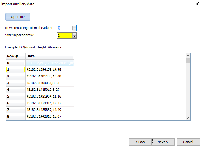
The csv should contain a row with headers, where a header name should consist of only one word. On the next page the choice can be made to decide which columns will be imported.
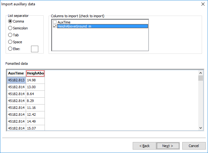
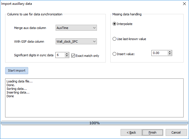
It is important that the csv contains a column that has values that correspond to a column in the detector data. Usually, and also in the example used in the pictures, this parameter is the time stamp. These two columns should be selected in the final page and their significant digits that should match can be chosen. If data is missing, for example when LIDAR data has been measured with a different frequency than detector data, Gamman can fill up the missing data points by linear interpolation or a fixed value. Clicking on “Start import” will add the columns to the detector data in Gamman. After clicking on “Finish” the columns are inserted into the raw data.
Performing the height corrections
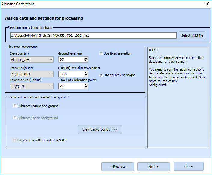
Now, all the information is needed to perform airborne corrections on the data. The tool can be opened through “Airb. corr. | Full-spectrum elevation correction.” After going through the intro page, some data need to be filled in. The first to be selected is the elevation correction database. This is a collection of height specific standard spectra that will be used to scale the calculated radionuclide concentrations according to the height. For the detector models that can be used during drone surveys, the MS-350, 700, 1000 and 2000, the database goes up to a height of 40 meters, while the database for the MS-4000 goes up to 160 meters as these models are mostly used in airplanes.
Under “Elevation corrections” three parameters that will affect the amount of air that can attenuate the radiation between the ground and the detector should be filled in. First, select the column with elevation values. If auxiliary data with absolute distances between ground and detector are imported and selected for the elevation, the ground level should be chosen as 0 meters. For a flat field (as in the picture below,) the altitude from the built in gps of the detector can be used as elevation and the ground level will be the altitude of the take-off point. A third option is to check the box with “Use fixed elevation.” Only use this when being sure that the drone has flown at a constant height above the ground.
The pressure and temperature columns can also be selected when the box “Use equivalent height” has been checked. These have a small effect when flying at a small height, so omitting these parameters will not cause a problem.
Under “Cosmic corrections and carrier background” some background spectra can be selected that the airborne corrections will substract from the measured data. When doing drone-borne measurements, these backgrounds are usually not available and do not have a large enough effect for them to be included in the height corrections. Background from cosmic radiation will be more present when flying much higher where the signal from terrestrial radiation has already become much smaller.
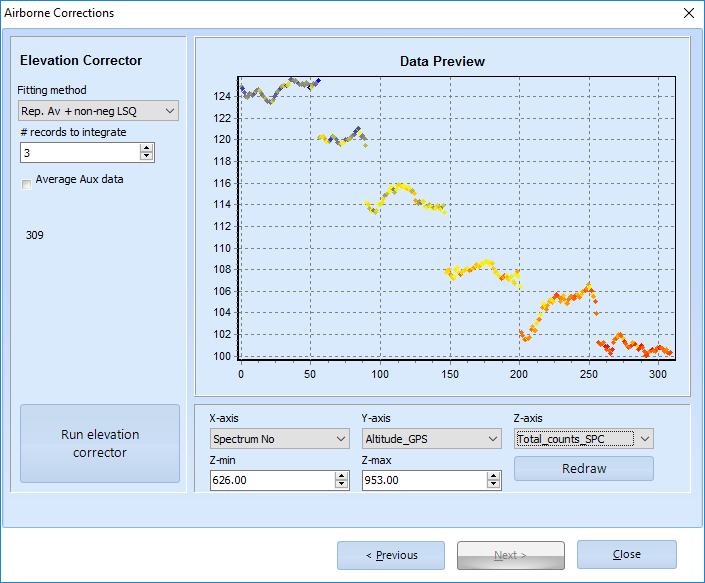
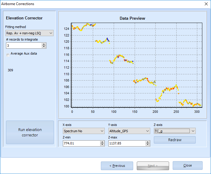
On the final page of the airborne corrections, the fitting method can be chosen and the elevation corrector can be run. After running, columns of the corrected total counts and radionuclide concentrations are created and can be visualised in the “Data Preview” plot. In the pictures below, the total counts before and after airborne correction are compaired. In this survey there has been flown at different heights the same x,y-position. It can be seen from the first picture that the detector registered more counts at lower altitudes, while the second picture shows that this effect is gone after airborne corrections.
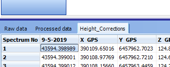
If the results of the height corrections look good, the airborne correction tool can be closed. The tool will ask to give the airborne corrections a name. When done, a new tab is created which contains all raw data columns that were present during the corrections with additional columns with corrected radionuclide concentrations and corrected total counts. These column names have a “_g” suffix where “g” refers to “ground.” When performing airborne corrections again, a new tab will be created.
The airborne corrected data can be exported at “File | Export results…” where the box “Processed data” needs to be checked. Then one csv file for every extra tab besides “Raw data” will be produced. So if the Gamman file contains a tab with processed data and two tabs with airborne corrected data, three separate csv files will be saved.